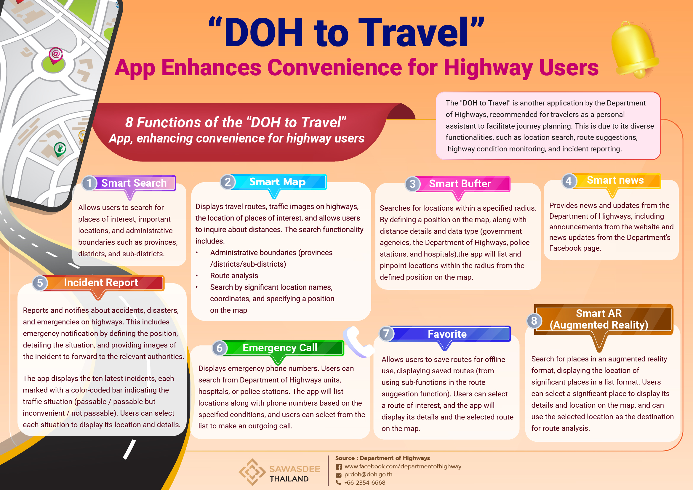
"DOH to Travel" App Enhances Convenience for Highway Users
The "DOH to Travel" is yet another application by the Department of Highways, recommended for travelers as a personal assistant to facilitate journey planning. This is due to its diverse functionalities, such as location search, route suggestions, highway condition monitoring, and incident reporting.
DOH to Travel also allows real-time access to highway data 24/7, along with route analysis and traffic status via CCTV feeds. The application is available in two formats: a mobile application and a web application. The "DOH to Travel" can be downloaded through the Apple App Store and Google Play, compatible with Android version 4.0.3 and above, as well as iOS version 8.0 and above.
The application's features can be divided as follows:
- Smart Search: Allows users to search for places of interest, important locations, and administrative boundaries such as provinces, districts, and sub-districts.
- Smart Map: Displays travel routes, traffic images on highways, the location of places of interest, and allows users to inquire about distances. The search functionality includes:
- Administrative boundaries (provinces/districts/sub-districts)
- Route analysis
- Search by significant location names, coordinates, and specifying a position on the map.
- Smart Buffer: Searches for locations within a specified radius. By defining a position on the map, along with distance details and data type (government agencies, the Department of Highways, police stations, and hospitals), the app will list and pinpoint locations within the radius from the defined position on the map.
- Smart news: Provides news and updates from the Department of Highways, including announcements from the website and news updates from the Department's Facebook page.
- Incident Report: Reports and notifies about accidents, disasters, and emergencies on highways. This includes emergency notification by defining the position, detailing the situation, and providing images of the incident to forward to the relevant authorities.
The app displays the ten latest incidents, each marked with a color-coded bar indicating the traffic situation (passable / passable but inconvenient / not passable). Users can select each situation to display its location and details.
- Emergency Call: Displays emergency phone numbers. Users can search from Department of Highways units, hospitals, or police stations. The app will list locations along with phone numbers based on the specified conditions, and users can select from the list to make an outgoing call.
- Favorite: Allows users to save routes for offline use, displaying saved routes (from using sub-functions in the route suggestion function). Users can select a route of interest, and the app will display its details and the selected route on the map.
- Smart AR (Augmented Reality): Search for places in an augmented reality format, displaying the location of significant places in a list format. Users can select a significant place to display its details and location on the map, and can use the selected location as the destination for route analysis.
Source: Department of Highways
Tel. +66 2354 6668